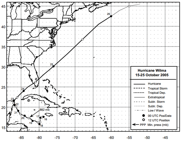
Hurricane Wilma occurred between 15 and 25 October 2005. Maximum sustained winds were estimated to be near 105 kt (category 3 intensity) when landfall of the center occurred in southwestern Florida near Cape Romano. The southeastern Florida peninsula experienced at least category 1 hurricane conditions, and that some parts of northern Miami-Dade County, Broward, and Palm Beach Counties likely had category 2 hurricane conditions. Storm surges of 4 to 5 feet were observed over much of the lower and middle Florida Keys, locally to near 7 feet. There was a total of 5 fatalities in the United States with about $20.6 billion property damage [NOAA, 2006]1.

Figure: Best track positions for Hurricane Wilma, 15-25 October 2005 (Source: NOAA1)
1Pasch, R. J., Blake, E. S., Cobb III, H. D., and Roberts, J. P., (January 2006), Tropical Cyclone Report Hurricane Wilma 15-25 October 2005, National Oceanic and Atmospheric Administration – National Hurricane Center.
Imagery
| File Name | Description | Source |
|---|---|---|
| Hurricane Wilma Response Imagery Viewer | Hurricane Wilma Response Images | NOAA - National Geodetic Survey - Emergency Response Imagery |
Miscellaneous
| File Name | Description | Source |
|---|---|---|
| Wilma 2005 | Including tropical cyclone report, aircraft missions, surface wind field analyses, satellite pictures, wind centers and tracks, radar composites, stepped frequency microwave radiometer, dropsonde data, and photos from flights | NOAA – Atlantic Oceanographic & Meteorological Laboratory |
Report
| File Name | Description | Source |
|---|---|---|
| Hurricane Wilma Post Storm Data Acquisition Estimated Peak Wind Analysis And Storm Tide Data | A report on the efforts of post storm data acquisition, estimated peak wind analysis and storm tide data of Hurricane Wilma | NOAA – National Weather Service |
| Tropical Cyclone Report Hurricane Wilma | The National Hurricane Center's Tropical Cyclone Reports (formerly called Preliminary Reports) contain comprehensive information on each storm, including synoptic history, meteorological statistics, casualties and damages, and the post-analysis best track (six-hourly positions and intensities). | NOAA – National Hurricane Center |
| Atlantic Hurricane Season of 2005 | The Hurricane Season summaries include descriptions of named storms along with pertinent meteorological data and satellite imagery. | NOAA – National Hurricane Center |
| Monitoring the Storm Tide of Hurricane Wilma | Monitoring the Storm Tide of Hurricane Wilma in Southwestern Florida, October 2005 | USGS |

 Give to Florida Tech