/prod01/channel_54/media/fit-website/site-assets/images/FT-Horiz_crimson-gold.png)
/prod01/channel_54/media/header-images/whirl-header.jpg)
Hurricane Katrina occurred between 23 and 30 August 2005. It first caused fatalities and damage in southern Florida as a category 1 hurricane. After reaching category 5 intensity over the central Gulf of Mexico, Katrina weakened to category 3 before making landfall on the northern Gulf coast. It was the costliest and one of the five deadliest hurricanes to ever strike the United States. Inundation up to 24-28 feet above ground level was observed along large portions of the Mississippi, Louisiana, Alabama, and Florida coast. The strongest sustained wind measured from a fixed location at the surface was 76 knots. There was a total of 1833 fatalities in the United States with about $108 billion property damage [NOAA, 2005]1.
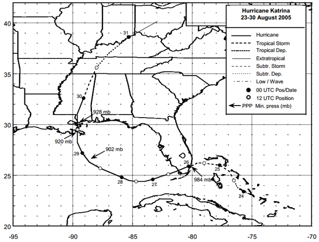
Figure: Best track positions for Hurricane Katrina, 23-30 August 2005 (Source: NOAA1)
1Knabb, R.D, Rhome, J. R., and Brown, D. P. (December 2005), Tropical Cyclone Report Hurricane Katrina 23-30 August 2005, National Oceanic and Atmospheric Administration – National Hurricane Center.
Imagery
| File Name | Description | Source |
|---|---|---|
| Hurricane Katrina Response Imagery Viewer | Hurricane Katrina Response Images | NOAA - National Geodetic Survey - Emergency Response Imagery |
| Hazards Data Distribution System | Aerial imagery of the region | USGS |
| Satellite Images and Aerial Photographs of the Effects of Hurricanes Katrina and Rita on Coastal Louisiana | Comparison of Landsat Thematic Mapper (TM) satellite imagery acquired before and after the landfalls of Katrina and Rita and classified to identify land and water demonstrated that water area increased by 217 mi2 (562 km2) in coastal Louisiana as a result of the storms | USGS |
Miscellaneous
| File Name | Description | Source |
|---|---|---|
| Hurricane Katrina 2005 | Including tropical cyclone report, aircraft missions, surface wind field analyses, satellite pictures, wind centers and tracks, radar composites, stepped frequency microwave radiometer, dropsonde data, and photos from flights | NOAA – Atlantic Oceanographic & Meteorological Laboratory |
Report
| File Name | Description | Source |
|---|---|---|
| Post Storm Data Acquisition Aerial Wind Analysis And Damage Assessment Hurricane Katrina | A report on the efforts of post storm data acquisition, aerial wind analysis and damage assessment of Hurricane Katrina | NOAA – National Weather Service |
| Tropical Cyclone Report Hurricane Katrina | The National Hurricane Center's Tropical Cyclone Reports (formerly called Preliminary Reports) contain comprehensive information on each storm, including synoptic history, meteorological statistics, casualties and damages, and the post-analysis best track (six-hourly positions and intensities). | NOAA – National Hurricane Center |
| Atlantic Hurricane Season of 2005 | The Hurricane Season summaries include descriptions of named storms along with pertinent meteorological data and satellite imagery. | NOAA – National Hurricane Center |
| Service Assessment: Hurricane Katrina August 23-31, 2005 | The NWS conducts service assessments of significant weather-related events that result in at least one fatality, numerous injuries requiring hospitalization, extensive property damage, widespread media interest, or an unusual level of scrutiny of NWS operations by the media, EMs, or elected officials. The intent of service assessments is to thoroughly evaluate the NWS performance and ensure the effectiveness of NWS products and services in meeting its mission. | NOAA - National Weather Service |
| Mapping and Visualization of Storm-Surge Dynamics for Hurricane Katrina and Hurricane Rita | This report uses some of the same data sources as the FEMA products but extends the storm-surge mapping to larger areas and provides additional derived storm-surge datasets through different presentation methods. | USGS |
| Land Area Changes in Coastal Louisiana After Hurricanes Katrina and Rita | Analysis of land loss or change to water immediately after Hurricanes Katrina and Rita | USGS |
| Post Storm Assessment Report For Hurricane Katrina And Hurricane Rita | This report includes an analysis of project features, commentary on marsh conditions, as appropriate, and recommendations for repair of damaged project features | State of Louisiana – Department of Natural Resources |
| FEMA 549, Hurricane Katrina in the Gulf Coast: Mitigation Assessment Team Report, Building Performance Observations, Recommendations, and Technical Guidance | In response to Hurricane Katrina, FEMA deployed a Mitigation Assessment Team (MAT) to evaluate and assess damage from the hurricane and provide observations, conclusions, and recommendations on the performance of buildings and other structures impacted by wind and flood forces. The conclusions and recommendations of the report provide decision-makers with information and technical guidance that can be used to reduce future hurricane damage. | FEMA |
Scientific Paper
| File Name | Description | Source |
|---|---|---|
| New Orleans and Hurricane Katrina. IV: Orleans East Bank „Metro… Protected Basin | This paper addresses damage caused by Hurricane Katrina to the main Orleans East Bank protected basin | Journal of Geotechnical And Geoenvironmental Engineering |