/prod01/channel_54/media/fit-website/site-assets/images/FT-Horiz_crimson-gold.png)
/prod01/channel_54/media/header-images/whirl-header.jpg)
Hurricane Isaac occurred between 21 August and 1 September 2012. It became a category 1 hurricane a few hours before making landfall in southeastern Louisiana. Hurricane Isaac caused extensive storm surge and inland flooding over southern Mississippi and southeastern Louisiana. Inundation up to 13.5 feet above ground level was observed along large portions of the Louisiana, Mississippi, Alabama and Florida coast. Maximum sustained winds up to 75 knots were recorded during this Hurricane in the United States. There was a total of 5 fatalities in the United States with about $2.35 billion property damage [NOAA, 2013]1.
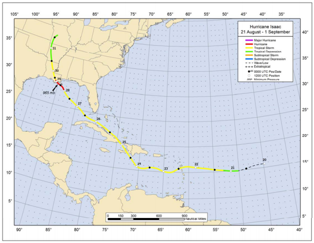
Figure: Best track positions for Hurricane Isaac, 21 August – 1 September 2012. (Source: NOAA1)
1Berg, R., (January 2013), Tropical Cyclone Report Hurricane Isaac (AL092012) 21 August – 1 September 2012, National Oceanic and Atmospheric Administration – National Hurricane Center.
Imagery
| File Name | Description | Source |
|---|---|---|
| Hurricane Isaac Response Imagery Viewer | Hurricane Isaac Response Images | NOAA - National Geodetic Survey - Emergency Response Imagery |
| Hazards Data Distribution System | Aerial imagery of the region | USGS |
Miscellaneous
| File Name | Description | Source |
|---|---|---|
| Hurricane Isaac 2012 | Including tropical cyclone report, aircraft missions, surface wind field analyses, satellite pictures, wind centers and tracks, radar composites, stepped frequency microwave radiometer, dropsonde data, and photos from flights | NOAA – Atlantic Oceanographic & Meteorological Laboratory |
Presentation
| File Name | Description | Source |
|---|---|---|
| Hurricane Isaac | An overall presentation about Hurricane Isaac, some benchmarks, and its damage | NOAA – National Hurricane Center |
Report
| File Name | Description | Source |
|---|---|---|
| Tropical Cyclone Report Hurricane Isaac | The National Hurricane Center's Tropical Cyclone Reports (formerly called Preliminary Reports) contain comprehensive information on each storm, including synoptic history, meteorological statistics, casualties and damages, and the post-analysis best track (six-hourly positions and intensities). | NOAA – National Hurricane Center |
| FEMA P-938, Hurricane Isaac In Louisiana: Mitigation Assessment Team Report, Building Performance Observations Recommendations, And Technical Guidance | In response to Hurricane Isaac, the Federal Emergency Management Agency (FEMA) deployed a Mitigation Assessment Team (MAT) to evaluate and assess damage from the hurricane and provide observations, conclusions, and recommendations on the performance of buildings and other structures impacted by wind and flood forces. The MAT included representatives from FEMA Headquarters and other Federal agencies, local government officials, academia, and experts from the design and construction industry. The conclusions and recommendations of this report are intended to provide decision-makers with information and technical guidance that can be used to reduce future hurricane damage. | FEMA |
| Monitoring Storm Tide and Flooding from Hurricane Isaac | Monitoring Storm Tide and Flooding from Hurricane Isaac along the Gulf Coast of the United States, August 2012 | USGS |
| Hurricane Isaac: Observations and Analysis of Coastal Change | This report documents data-collection efforts and presents qualitative and quantitative descriptions of hurricane-induced changes to the shoreline, beaches, dunes, and infrastructure in the region that was heavily impacted by Hurricane Isaac. | USGS |