/prod01/channel_54/media/fit-website/site-assets/images/FT-Horiz_crimson-gold.png)
/prod01/channel_54/media/header-images/whirl-header.jpg)
Hurricane Dennis occurred between 4 and 13 July 2005. It was intensified into a Category 4 hurricane near Cuba. Hurricane Dennis made landfall on Santa Rosa Island, Florida, between Navarre Beach and Gulf Breeze as a category 1 hurricane. As Hurricane Dennis continued to go up north towards southwestern Alabama it weakened into a tropical storm. Inundation up to 6-7 feet above ground level was observed along portions of the Florida, Alabama, Mississippi, and southeastern Louisiana coast. Maximum sustained winds up to 86 knots were recorded during this Hurricane in the United States. There was a total of 3 fatalities in the United States with about $2.23 billion property damage [NOAA, 2005]1.
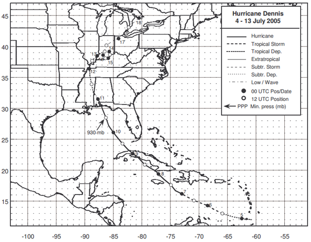
Figure: Best track positions for Hurricane Dennis, 4-13 July 2005 (Source: NOAA1)
1Beven, J., (November 2005), Tropical Cyclone Report Hurricane Dennis 4 – 13 July 2005, National Oceanic and Atmospheric Administration – National Hurricane Center.
Imagery
| File Name | Description | Source |
|---|---|---|
| Hurricane Dennis Response Imagery Viewer | Hurricane Dennis Response Images | NOAA - National Geodetic Survey - Emergency Response Imagery |
Miscellaneous
| File Name | Description | Source |
|---|---|---|
| Hurricane Dennis 2005 | Including tropical cyclone report, aircraft missions, surface wind field analyses, satellite pictures, wind centers and tracks, radar composites, stepped frequency microwave radiometer, dropsonde data, and photos from flights | NOAA – Atlantic Oceanographic & Meteorological Laboratory |
Report
| File Name | Description | Source |
|---|---|---|
| Tropical Cyclone Report Hurricane Dennis | The National Hurricane Center's Tropical Cyclone Reports (formerly called Preliminary Reports) contain comprehensive information on each storm, including synoptic history, meteorological statistics, casualties and damages, and the post-analysis best track (six-hourly positions and intensities). | NOAA – National Hurricane Center |
| Atlantic Hurricane Season of 2005 | The Hurricane Season summaries include descriptions of named storms along with pertinent meteorological data and satellite imagery. | NOAA – National Hurricane Center |
| Coastal Change During Hurricane Dennis 2005 | Coastal Change During Hurricane Dennis 2005 | USGS |