/prod01/channel_54/media/fit-website/site-assets/images/FT-Horiz_crimson-gold.png)
/prod01/channel_54/media/header-images/whirl-header.jpg)
Hurricane Frances occurred between 25 August and 8 September 2004. It reached a peak intensity of category 4 on the Saffir-Simpson Hurricane Scale. It affected the Bahamas as a category 3 hurricane and the Florida east coast as a category 2 hurricane. Frances produced notable storm surges along both the Atlantic and Gulf coasts of Florida. The highest measured storm surge was 5.89 feet above mean sea level on the Florida east coast at the St. Lucie Lock. The National Weather Service Melbourne Weather Forecast Office (WFO) estimated storm surge at 8 feet near Vero Beach and 6 feet around Cocoa Beach. Maximum sustained winds up to 74 knots were recorded during this Hurricane in the United States. There was a total of 6 fatalities in the United States with about $9 billion property damage [NOAA, 2004]1.
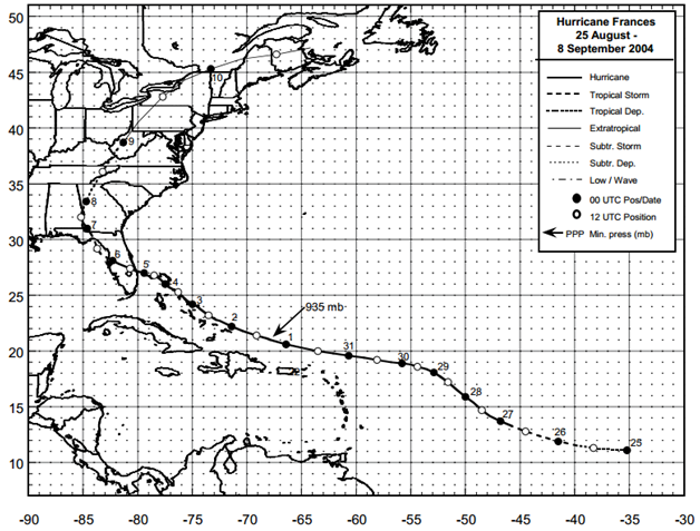
Figure: Best track positions for Hurricane Frances, 25 August – 8 September 2004 (Source: NOAA1)
1Beven II, J. L., (December 2004), Tropical Cyclone Report Hurricane Frances 25 August – 8 September 2004, National Oceanic and Atmospheric Administration – National Hurricane Center.
Miscellaneous
| File Name | Description | Source |
|---|---|---|
| Hurricane Frances 2004 | Including tropical cyclone report, aircraft missions, surface wind field analyses, satellite pictures, wind centers and tracks, radar composites, stepped frequency microwave radiometer, dropsonde data, and photos from flights | NOAA – Atlantic Oceanographic & Meteorological Laboratory |
Report
| File Name | Description | Source |
|---|---|---|
| Post Storm Data Acquisition Aerial Wind Mapping Mission Hurricane Frances - 2004 | A report on the efforts of post storm data acquisition and aerial wind mapping of Hurricane Frances | NOAA – National Weather Service |
| Tropical Cyclone Report Hurricane Frances | The National Hurricane Center's Tropical Cyclone Reports (formerly called Preliminary Reports) contain comprehensive information on each storm, including synoptic history, meteorological statistics, casualties and damages, and the post-analysis best track (six-hourly positions and intensities). | NOAA – National Hurricane Center |
| Atlantic Hurricane Season of 2004 | The Hurricane Season summaries include descriptions of named storms along with pertinent meteorological data and satellite imagery. | NOAA – National Hurricane Center |
| FEMA 490, Mitigation Assessment Team Report: Summary Report on Building Performance 2004 Hurricane Season (2005) | The purpose of this document is to summarize the observations, conclusions, and recommendations that were obtained during post-disaster assessments sponsored by the FEMA Mitigation Division in response to Florida 2004 hurricane season. More than ten rapid response teams and two Mitigation Assessment Teams (MATs) were deployed to document observations and provide recommendations. The rapid response data collection teams focused on coastal high water marks, inland wind effects, residential and commercial building performance, critical and essential facility performance, and mitigation program effectiveness. The MATs assessed damage to the built environment and relied on the perishable data, such as high water marks, collected by the rapid response teams to quantify flood and wind effects of the hurricanes. | FEMA |
| Floods in Southwest-Central Florida from Hurricane Frances | Floods in Southwest-Central Florida from Hurricane Frances, September 2004 | USGS |