/prod01/channel_54/media/fit-website/site-assets/images/FT-Horiz_crimson-gold.png)
/prod01/channel_54/media/header-images/whirl-header.jpg)
Hurricane Ivan occurred between 2 and 24 September 2004. It reached Category 5 strength three times on the Saffir-Simpson Hurricane Scale. It made landfall as a 105 knots hurricane (category 3) just west of Gulf Shores, Alabama. Storm surge of 10-15 feet occurred along the coasts from Destin in the Florida panhandle westward to Mobile Bay/Baldwin County, Alabama. Storm surge values of 6-9 feet were observed from Destin eastward to St. Marks in the Florida Big Bend region. Lesser values of storm surge continued east and southward along the Florida west coast with 3.5 feet reported in Hillsborough Bay/Tampa Bay. Maximum sustained winds up to 76 knots were recorded during this Hurricane in the United States. There was a total of 25 fatalities in the United States [NOAA, 2005]1.
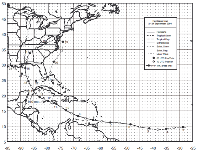
Figure: Best track positions for Hurricane Ivan, 2-24 September 2004 (Source: NOAA1)
1Stewart, S. R., (May 2005), Tropical Cyclone Report Hurricane Ivan 2-24 September 2004, National Oceanic and Atmospheric Administration – National Hurricane Center.
Imagery
| File Name | Description | Source |
|---|---|---|
| Hurricane Ivan Response Imagery Viewer | Hurricane Ivan Response Images | NOAA - National Geodetic Survey - Emergency Response Imagery |
Miscellaneous
| File Name | Description | Source |
|---|---|---|
| Hurricane Ivan 2004 | Including tropical cyclone report, aircraft missions, surface wind field analyses, satellite pictures, wind centers and tracks, radar composites, stepped frequency microwave radiometer, dropsonde data, and photos from flights | NOAA – Atlantic Oceanographic & Meteorological Laboratory |
Report
| File Name | Description | Source |
|---|---|---|
| Hurricane Ivan | Beach And Dune Erosion And Structural Damage Assessment And Post-Storm Recovery Plan For The Panhandle Coast Of Florida | Department of Environmental Protection State of Florida |
| Post Storm Data Acquisition Aerial Wind Mapping Mission Hurricane Ivan - 2004 | A report on the efforts of post storm data acquisition and aerial wind mapping of Hurricane Ivan | NOAA – National Weather Service |
| Tropical Cyclone Report Hurricane Ivan | The National Hurricane Center's Tropical Cyclone Reports (formerly called Preliminary Reports) contain comprehensive information on each storm, including synoptic history, meteorological statistics, casualties and damages, and the post-analysis best track (six-hourly positions and intensities). | NOAA – National Hurricane Center |
| Coastal Change During Hurricane Ivan 2004 | Coastal Change During Hurricane Ivan 2004 | USGS |
| Atlantic Hurricane Season of 2004 | The Hurricane Season summaries include descriptions of named storms along with pertinent meteorological data and satellite imagery. | NOAA – National Hurricane Center |
| FEMA 489, Hurricane Ivan in Alabama and Florida: Observations, Recommendations and Technical Guidance (2005) | This report summarizes the observations, conclusions, and recommendations that resulted from post-disaster assessments sponsored by FEMA in response to Florida's 2004 hurricane season. During the 2004 season, the State was struck by Hurricanes Charley, Frances, Jeanne, and Ivan. More than 10 rapid-response teams and two Mitigation Assessment Teams were deployed to document observations and provide recommendations concerning building performance under the effects of hurricane winds and hurricane-related flooding. The information presented in this report is intended to assist the States of Florida and Alabama, communities, businesses, and individuals in the reconstruction process. This information will also help reduce future wind and water damage and promote the economic well-being of the nation. | FEMA |