Hurricane Ike (2008)
Hurricane Ike occurred between 1 and 14 September 2008. It peaked as a Category 4 hurricane over the open waters of the central Atlantic. It made landfall along the upper Texas coast at the upper end of Category 2 intensity. Inundation up to 13 feet above ground level was observed along large portions of the Texas, Louisiana, Mississippi, Alabama and Florida coast. Maximum sustained winds up to 83 knots were recorded during this Hurricane in the United States. There was a total of 21 fatalities in the United States with about $12.5 billion property damage [NOAA, 2009]1.
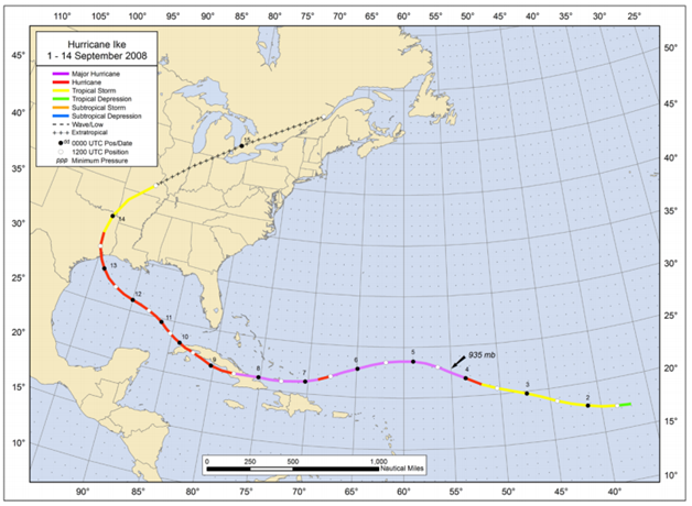
Figure: Best track positions for Hurricane Ike, 1 – 14 September 2008 (Source: NOAA1)
1Berg, R., (January 2009), Tropical Cyclone Report Hurricane Ike (AL092008) 1 - 14 September 2008, National Oceanic and Atmospheric Administration – National Hurricane Center.
Book
Imagery
Miscellaneous
| File Name | Description | Source |
|---|
| Ike 2008 |
Including tropical cyclone report, aircraft missions, surface wind field analyses, satellite pictures, wind centers and tracks, radar composites, stepped frequency microwave radiometer, dropsonde data, and photos from flights |
NOAA – Atlantic Oceanographic & Meteorological Laboratory |
Report
| File Name | Description | Source |
|---|
| Hurricane Ike Wind Investigation Report |
This report covers investigations conducted between September 19 and September 21, 2008. |
Roofing Industry Committee on Weather Issues, Inc. |
| Hurricane Ike |
Hurricane Ike Wind Analysis For Southeast Texas |
NOAA – National Weather Service Weather Forecast Office |
| Tropical Cyclone Report Hurricane Ike |
The National Hurricane Center's Tropical Cyclone Reports (formerly called Preliminary Reports) contain comprehensive information on each storm, including synoptic history, meteorological statistics, casualties and damages, and the post-analysis best track (six-hourly positions and intensities). |
NOAA – National Hurricane Center |
| Global Positioning System Surveys of Storm-Surge Sensors Deployed During Hurricane Ike, Seadrift, Texas, to Lake Charles, Louisiana, 2008 |
This report summarizes the GPS data collected and processed to obtain reference marks and storm-sensor-orifice elevations for 59 of the 65 storm-surge sensors installed along the Texas and Louisiana coast. |
USGS |
| Hurricane Ike: Observations and Analysis of Coastal Change |
This report documents the data-collection efforts and presents qualitative and quantitative descriptions of hurricane-induced changes to the shoreline, beaches, dunes, and infrastructure in the region that was heavily impacted by Hurricane Ike |
USGS |
| Monitoring Inland Storm Surge and Flooding from Hurricane Ike |
Monitoring Inland Storm Surge and Flooding from Hurricane Ike in Texas and Louisiana, September 2008 |
USGS |
| FEMA P-757, Hurricane Ike In Texas And Louisiana: Mitigation Assessment Team Report, Building Performance Observations, Recommendations, And Technical Guidance (2009) |
In response to Hurricane Ike, the Federal Emergency Management Agency (FEMA) deployed a Mitigation Assessment Team (MAT) to evaluate and assess damage from the hurricane and provide observations, conclusions, and recommendations on the performance of buildings and other structures impacted by wind and flood forces. The MAT included FEMA Headquarters and Regional Office engineers, representatives from other Federal agencies and academia, and experts from the design and construction industry. The conclusions and recommendations of this Report are intended to provide decision-makers with information and technical guidance that can be used to reduce future hurricane damage. |
FEMA |
Scientific Paper
/prod01/channel_54/media/fit-website/site-assets/images/FT-Horiz_crimson-gold.png)
/prod01/channel_54/media/header-images/whirl-header.jpg)