/prod01/channel_54/media/fit-website/site-assets/images/FT-Horiz_crimson-gold.png)
/prod01/channel_54/media/header-images/whirl-header.jpg)
Hurricane Irene occurred between 21 and 28 August 2011. It was classified as a category 3 hurricane hitting the Bahamas. However, before reaching southeastern United States it weakened and by the time it hit North Carolina it was a category 1 hurricane. Hurricane Irene caused widespread damage across a large portion of the eastern United States as it moved through New England. The most severe impact of Irene in the northeastern United States was catastrophic inland flooding in New Jersey, Massachusetts and Vermont. Inundation up to 7 feet above ground level was observed along large portions of the east coast. Maximum sustained winds up to 71 knots were recorded during this Hurricane in the United States. There was a total of 41 fatalities in the United States with about $4.3 billion property damage [NOAA, 2011]1.
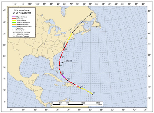
Figure: Best track positions for Hurricane Irene, 21 -28 August 2011 (Source: NOAA1)
1Avila, L. A., and Cangialosi, J., (December 2011), Tropical Cyclone Report Hurricane Irene (AL092011) 21-28 August 2011, National Oceanic and Atmospheric Administration – National Hurricane Center.
Imagery
| File Name | Description | Source |
|---|---|---|
| Hurricane Irene Response Imagery Viewer | Hurricane Irene Response Images | NOAA - National Geodetic Survey - Emergency Response Imagery |
| Hazards Data Distribution System | Aerial imagery of the region | USGS |
Miscellaneous
| File Name | Description | Source |
|---|---|---|
| Hurricane Irene 2011 | Including tropical cyclone report, aircraft missions, surface wind field analyses, satellite pictures, wind centers and tracks, radar composites, stepped frequency microwave radiometer, dropsonde data, and photos from flights | NOAA – Atlantic Oceanographic & Meteorological Laboratory |
Report
| File Name | Description | Source |
|---|---|---|
| Tropical Cyclone Report Hurricane Irene | The National Hurricane Center's Tropical Cyclone Reports (formerly called Preliminary Reports) contain comprehensive information on each storm, including synoptic history, meteorological statistics, casualties and damages, and the post-analysis best track (six-hourly positions and intensities). | NOAA – National Hurricane Center |
| Service Assessment: Hurricane Irene, August 21–30, 2011 | The NWS conducts service assessments of significant weather-related events that result in at least one fatality, numerous injuries requiring hospitalization, extensive property damage, widespread media interest, or an unusual level of scrutiny of NWS operations by the media, EMs, or elected officials. The intent of service assessments is to thoroughly evaluate the NWS performance and ensure the effectiveness of NWS products and services in meeting its mission. | NOAA - National Weather Service |
| Hurricane Irene and Associated Floods of August 27–30, 2011, in New Jersey | Documented flood conditions on stream reaching throughout the State of New Jersey as a result of Hurricane Irene | USGS |
| Monitoring Inland Storm Tide and Flooding from Hurricane Irene along the Atlantic Coast of the United States, August 2011 | The U.S. Geological Survey (USGS) deployed a temporary monitoring network of water-level sensors at 212 locations along the Atlantic coast from South Carolina to Maine during August 2011 to record the timing, areal extent, and magnitude of inland hurricane storm tide and coastal flooding generated by Hurricane Irene. Water-level sensor locations were selected to augment existing tide-gauge networks to ensure adequate monitoring in areas forecasted to have substantial storm tide. | USGS |