/prod01/channel_54/media/fit-website/site-assets/images/FT-Horiz_crimson-gold.png)
/prod01/channel_54/media/header-images/whirl-header.jpg)
Hurricane Rita occurred between 18 and 26 September 2005. It reached Category 5 strength over the central Gulf of Mexico. It weakened prior to making landfall as a Category 3 hurricane near the Texas/Louisiana border. Rita produced significant storm surge that devastated coastal communities in southwestern Louisiana, and its winds, rain, and tornadoes caused fatalities and a wide swath of damage from eastern Texas to Alabama. Additionally, Rita caused floods due to storm surge in portions of the Florida Keys. Inundation up to 15 feet above ground level was observed along large portions of eastern Texas to the Florida coast. Maximum sustained winds up to 71 knots were recorded during this Hurricane in the United States. There was a total of 7 fatalities in the United States with about $12.04 billion property damage [NOAA, 2006]1.
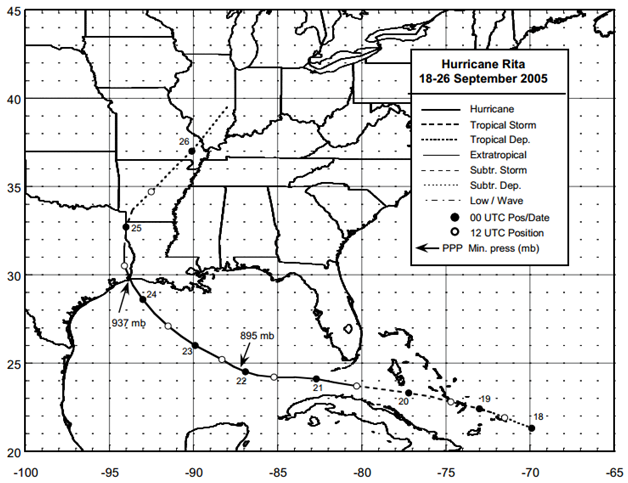
Figure: Best track positions for Hurricane Rita, 18-26 September 2005 (Source: NOAA1)
1Knabb, R. D., Brown, D. P. and Rhome, J. R., (March 2006), Tropical Cyclone Report Hurricane Rita 18-26 September 2005, National Oceanic and Atmospheric Administration – National Hurricane Center.
Imagery
| File Name | Description | Source |
|---|---|---|
| Hurricane Rita Response Imagery Viewer | Hurricane Rita Response Images | NOAA - National Geodetic Survey - Emergency Response Imagery |
| Satellite Images and Aerial Photographs of the Effects of Hurricanes Katrina and Rita on Coastal Louisiana | Comparison of Landsat Thematic Mapper (TM) satellite imagery acquired before and after the landfalls of Katrina and Rita and classified to identify land and water demonstrated that water area increased by 217 mi2 (562 km2) in coastal Louisiana as a result of the storms | USGS |
Miscellaneous
| File Name | Description | Source |
|---|---|---|
| Rita 2005 | Including tropical cyclone report, aircraft missions, surface wind field analyses, satellite pictures, wind centers and tracks, radar composites, stepped frequency microwave radiometer, dropsonde data, and photos from flights | NOAA – Atlantic Oceanographic & Meteorological Laboratory |
Report
| File Name | Description | Source |
|---|---|---|
| Post Storm Data Acquisition – Hurricane Rita Peak Wind Gust Analysis and Storm Surge Data | A report on the efforts of post storm data acquisition, peak wind gust analysis and storm surge data of Hurricane Rita | NOAA – National Weather Service |
| Tropical Cyclone Report Hurricane Rita | The National Hurricane Center's Tropical Cyclone Reports (formerly called Preliminary Reports) contain comprehensive information on each storm, including synoptic history, meteorological statistics, casualties and damages, and the post-analysis best track (six-hourly positions and intensities). | NOAA – National Hurricane Center |
| Atlantic Hurricane Season of 2005 | The Hurricane Season summaries include descriptions of named storms along with pertinent meteorological data and satellite imagery. | NOAA – National Hurricane Center |
| Mapping and Visualization of Storm-Surge Dynamics for Hurricane Katrina and Hurricane Rita | This report uses some of the same data sources as the FEMA products but extends the storm-surge mapping to larger areas and provides additional derived storm-surge datasets through different presentation methods. | USGS |
| Land Area Changes in Coastal Louisiana After Hurricanes Katrina and Rita | Analysis of land loss or change to water immediately after Hurricanes Katrina and Rita | USGS |
| Monitoring Inland Storm Surge and Flooding from Hurricane Rita | Pressure transducers (sensors) comparison to high water marks during Hurricane Rita | USGS |
| Hurricane Rita Surge Data | Hurricane Rita Surge Data, Southwestern Louisiana and Southeastern Texas, September to November 2005 | USGS |
| Post Storm Assessment Report For Hurricane Katrina And Hurricane Rita | This report includes an analysis of project features, commentary on marsh conditions, as appropriate, and recommendations for repair of damaged project features | State of Louisiana – Department of Natural Resources |